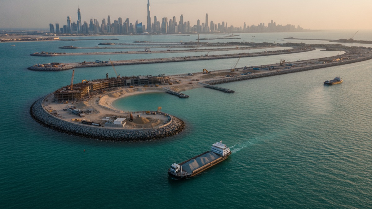
Dubai's natural coastline runs for roughly 70 kilometres along the Arabian Gulf, a modest stretch for a city that has built some of the most photographed waterfront real estate on Earth. Rather than accept that natural limit, planners chose to manufacture hundreds of additional kilometres of coastline from dredged seabed sand, reshaping the emirate's entire relationship to the sea in barely two decades.
The decision looks spectacular from a satellite image, but it was never primarily about spectacle. It was a fairly direct response to a land-economics problem: a small territory with an oil endowment that officials knew would not fund the economy indefinitely, and a finite coastline that happened to be the single most valuable category of land the emirate possessed.
Dubai's Coastline Problem
Unlike neighbouring Abu Dhabi, Dubai never held a large share of the UAE's proven oil reserves, and by the late 1990s its own oil output was already declining relative to the rest of the federation. Government planners needed an economic base that did not depend on a resource in gradual decline, and tourism, aviation, trade, and real estate emerged as the deliberate substitutes.
Each of those substitute industries benefits disproportionately from waterfront property, whether as hotel frontage, marina access, or simply the view that lets an apartment command a premium price. The problem was that Dubai's actual coastline, at roughly 70km, could only ever support a limited number of such waterfront addresses, no matter how the existing shore was subdivided or redeveloped.
Waterfront Land Is Worth More Than Inland Land
Real estate economics consistently shows a substantial price premium for waterfront property over otherwise comparable inland property, driven by scarcity, view, and lifestyle appeal rather than any difference in construction cost. In a desert city where most of the surrounding land is functionally interchangeable flat terrain, that premium is unusually pronounced, since almost nothing else in the immediate landscape offers a comparably distinctive selling point.
Given a fixed natural coastline and a strong price premium attached specifically to waterfront frontage, the economically direct move is to manufacture more of exactly that scarce, premium-priced category of land rather than compete only within the fixed supply that nature provided. Reclamation is, in this framing, closer to a land-value strategy than an engineering stunt.
Why Reclamation Instead of Just Building Taller
Dubai has also built extremely tall towers, so height alone was clearly not the constraint reclamation was solving. Height increases usable floor area on a given plot, but it does nothing to increase the number of plots that can credibly claim direct beachfront or marina frontage, which is the specific attribute driving the premium.
A 200-metre tower a kilometre from the shore still does not carry the same market position as a low-rise villa with private beach access, so reclaiming new coastline addressed a different constraint than vertical construction ever could, expanding the supply of the specific asset class buyers were most willing to pay extra for. Developers understood this distinction clearly enough that even the tallest waterfront towers built later were marketed heavily on their proximity to reclaimed marina and beach frontage rather than height alone.
How Palm Jumeirah Was Actually Built
Palm Jumeirah, the first and most famous of the projects, was built by dredging millions of cubic metres of sand from the Gulf seabed and depositing it in a palm-tree-shaped outline defined by a surrounding crescent breakwater. The sand was pumped through pipelines and shaped in stages using a technique that lets each new layer settle before the next is added.
Contractors then applied vibro-compaction, driving vibrating probes into the reclaimed sand to densify it and reduce the risk of long-term settlement, a critical step given that loosely packed reclaimed sand can otherwise subside unevenly under the weight of villas, roads, and utilities built on top of it.
The final shape, sixteen fronds branching from a central trunk and enclosed by a crescent-shaped breakwater roughly 11 kilometres long, was chosen partly for engineering reasons and partly for marketing ones. The fronds maximise the number of individual plots that touch open water directly, while the overall silhouette, instantly recognisable from the air, became a branding asset in its own right well before a single villa was occupied.
Monorail, Utilities, and the Practical Challenge of Serving an Island
Building the shape was only the first phase; delivering electricity, freshwater, sewage treatment, and road access to a landmass that did not previously exist required an entirely new utility network laid beneath and across the reclaimed sand. A monorail line was added specifically to move residents and visitors along the trunk without adding further private vehicle congestion to the narrow access road.
Coordinating utility installation with ongoing sand settlement proved to be one of the more technically demanding parts of the project, since pipes and cabling had to be engineered with enough flexibility to tolerate gradual ground movement without cracking, a constraint that does not apply to infrastructure built on naturally stable, long-settled land, and one engineers had comparatively little precedent for at this particular scale.
What Happened to the World Islands
The follow-up project, an archipelago of roughly 300 small islands arranged to resemble a world map when viewed from above, was reclaimed in the mid-2000s at even greater cost and ambition than Palm Jumeirah. Individual islands were sold to private buyers and developers, with early marketing pitching them as ultra-exclusive private retreats.
Progress slowed sharply once the 2008-09 global financial crisis hit Dubai's property market particularly hard, and many islands sat largely undeveloped for years afterward. Some have since seen renewed construction activity under later ownership, while others remain in a considerably less finished state than original renderings suggested.
Erosion also became a genuine maintenance issue for several of the smaller, less-developed islands, since an undeveloped reclaimed island lacks the hard landscaping, sea walls, and continuous human presence that help stabilise a developed shoreline against wave action, meaning some islands visibly lost sand and shrank at their edges during the years construction stalled.
Why Dubai Kept Building After the 2009 Crash
The financial crisis briefly halted new large-scale reclamation announcements and forced a round of debt restructuring across several government-linked developers, but it did not permanently end the underlying strategy. Later projects, including Bluewaters Island and various expansions, resumed a similar logic once the market recovered, just with somewhat more conservative financing structures.
The core rationale, that manufactured waterfront land captures value a fixed coastline cannot, survived the crash largely intact, because the scarcity argument driving demand for that land had not actually changed, only the short-term financing conditions surrounding it.
The Freehold Ownership Rule That Made It All Sellable
A parallel legal change was arguably as important to the islands' commercial success as the engineering itself. In 2002, Dubai introduced freehold property ownership for foreign nationals in designated zones, a significant departure from the leasehold-only arrangements common elsewhere in the Gulf at the time.
Without that rule, the artificial islands would have had a drastically smaller pool of eligible buyers, since expatriates and international investors, who made up the overwhelming majority of purchasers, would have had no secure ownership mechanism to buy into. The reclamation projects and the legal reform were announced and marketed almost as a single package for this reason, with early Palm Jumeirah sales campaigns explicitly citing freehold eligibility alongside villa renderings.
Tourism as the Second Motive
Beyond direct real estate sales, the islands were explicitly designed to function as tourism infrastructure, adding hotel capacity, beach frontage, and a globally recognisable visual icon that could anchor marketing campaigns aimed at attracting visitors who might otherwise choose a competing regional destination.
Palm Jumeirah in particular became a genuine tourism draw in its own right, appearing in countless promotional images and functioning as a recognisable symbol of Dubai internationally in a way that arguably exceeded its purely commercial real estate value, generating a marketing return that is difficult to capture in property sale figures alone.
Hotel operators specifically sought sites on the reclaimed fronds because a private, gently sloping artificial beach could be engineered to a more consistent standard than most naturally occurring Gulf shorelines, which are often narrower or affected by seasonal currents; the ability to specify beach width and sand quality in advance was itself a selling point to international resort brands.
The Environmental Cost of Reclamation
Large-scale dredging and reclamation are not environmentally neutral. Removing seabed material and redistributing enormous volumes of sand can smother coral reefs, disturb seagrass beds that anchor local marine food chains, and alter natural currents and sediment transport patterns well beyond the immediate footprint of the project itself.
Environmental assessments of the early Dubai projects were considerably less rigorous than what is now standard practice for comparable Gulf reclamation schemes, and independent researchers have documented measurable impacts on nearby reef systems, a pattern that has pushed more recent regional projects toward stricter environmental review before construction begins.
Sediment plumes generated during dredging can travel well beyond the immediate construction site, reducing the light available to coral and seagrass that depend on clear water for photosynthesis, and studies of comparable Gulf reclamation projects have found measurable declines in coral cover extending several kilometres from active dredging zones. Because the Gulf's shallow, semi-enclosed geography limits how quickly disturbed sediment disperses, these effects can persist for years after construction itself has finished.
How Authorities Responded to the Criticism
Later projects incorporated design changes intended to reduce ecological disruption, including gaps deliberately left in breakwater structures to preserve some natural water circulation, and slower dredging schedules timed to avoid the most sensitive periods for local marine life such as coral spawning. Some developments also funded artificial reef structures intended to offset lost habitat, though independent researchers remain divided on how effectively these substitutes replicate a mature natural reef.
Regulatory bodies across the Gulf have gradually tightened environmental impact assessment requirements for new reclamation proposals, partly in direct response to the documented effects of the earliest Dubai-era projects, meaning a project resembling the original World Islands would face considerably more scrutiny if proposed today than it did in the mid-2000s.
Where the Sand Actually Comes From
Despite sitting at the edge of a vast desert, Dubai's reclamation projects did not use desert sand, because wind-blown desert sand grains are worn smooth and rounded, which prevents them from interlocking and compacting into stable structural fill in the way angular marine sand does.
Instead, dredging vessels extract sand directly from the Gulf seabed, transporting it relatively short distances before it is pumped ashore, a process that is itself a significant driver of the marine habitat disruption described above, since it directly removes material and alters the seafloor topography of the areas being dredged.
How Artificial Islands Are Engineered to Survive the Sea
Reclaimed land sitting directly in open water needs specific protection against wave action, storm surge, and gradual erosion that a naturally formed coastline has typically already adapted to over geological time. Engineers addressed this with substantial rock and concrete breakwaters positioned to absorb wave energy before it reaches the reclaimed sand itself.
Continuous monitoring programmes track subsidence and shoreline movement over time, since even well-compacted reclaimed land can shift gradually, and maintenance dredging is periodically required to replace sand lost to erosion along exposed edges, an ongoing cost that is easy to overlook in initial construction budgets and one that developers of naturally formed coastline rarely have to account for at all.
What Other Gulf Cities Learned From Dubai
Dubai's islands became a widely studied case study across the Gulf region, prompting other cities to pursue their own reclamation projects while trying to avoid the specific pitfalls, oversupply, financing fragility, and slower-than-expected environmental review, that had emerged during Dubai's own experience.
Subsequent projects elsewhere in the region have generally paired reclamation with more integrated master planning from the outset, sequencing infrastructure and demand more carefully rather than building speculative supply first and hoping buyers would follow, a direct lesson drawn from watching the World Islands sit partly unfinished for over a decade.
Qatar's Pearl-Qatar and Bahrain's various reclaimed districts both drew visibly on Dubai's freehold-ownership model to attract foreign buyers, while pairing it with phased construction schedules designed to avoid delivering large blocks of unsold inventory all at once, a financing discipline that Dubai's own early projects had notably lacked during their first speculative boom.
Dubai's artificial islands were never simply an engineering flex. They were a calculated response to a specific economic constraint, a fixed and modest natural coastline in a city that had decided its future depended on tourism and real estate rather than oil, paired with a legal reform that made the resulting land sellable to a global buyer pool.
That combination of manufactured scarcity-breaking supply, legal access for foreign capital, and aggressive international marketing explains both why the strategy worked commercially and why it has been imitated, imperfectly, across the wider Gulf region in the two decades since Palm Jumeirah's first sand was pumped ashore. The environmental cost of that success is real and increasingly well documented, and it now shapes how every subsequent reclamation project in the region gets approved, financed, and built.
Sources
- Wikipedia — overview of Palm Jumeirah's construction and history
- Wikipedia — background on the World Islands project
- Wikipedia — general land reclamation engineering methods
- Dubai Land Department — official data on Dubai real estate and freehold ownership zones
- International Union for Conservation of Nature — research on marine and coastal ecosystem impacts of reclamation
FAQ
Why did Dubai build artificial islands instead of just building taller?
Waterfront land commands a substantial price premium over inland land, and a fixed 70km coastline sharply limits how much of that premium-priced land exists; reclamation manufactures more of exactly the land type buyers pay the most for.
Is Palm Jumeirah sinking?
Engineering monitoring has not found evidence of significant large-scale sinking; the vibro-compaction process used during construction was specifically intended to densify the sand and reduce long-term settlement risk.
What happened to the original World Islands project?
Construction and sales slowed sharply after the 2008-09 financial crisis; some individual islands have since been developed while others remain largely undeveloped.
Where does the sand for Dubai's islands come from?
It is dredged from the seabed of the Gulf itself rather than imported from land, since desert sand grains are too smooth and rounded to compact into stable structural fill.
Do artificial islands damage marine ecosystems?
Large-scale dredging and reclamation can smother coral and seagrass and alter local currents and sediment patterns, which is why more recent Gulf projects face greater environmental scrutiny than earlier ones.
About the Author
We reference Wikipedia, the Dubai Land Department, and the International Union for Conservation of Nature to explain the background and current understanding of this topic.
Loved This Article?
Share it on WhatsApp → Share it on WhatsApp
Get more guides in your inbox — Subscribe to our newsletter for weekly surprising stories from Egypt, Saudi Arabia, Dubai, and beyond.