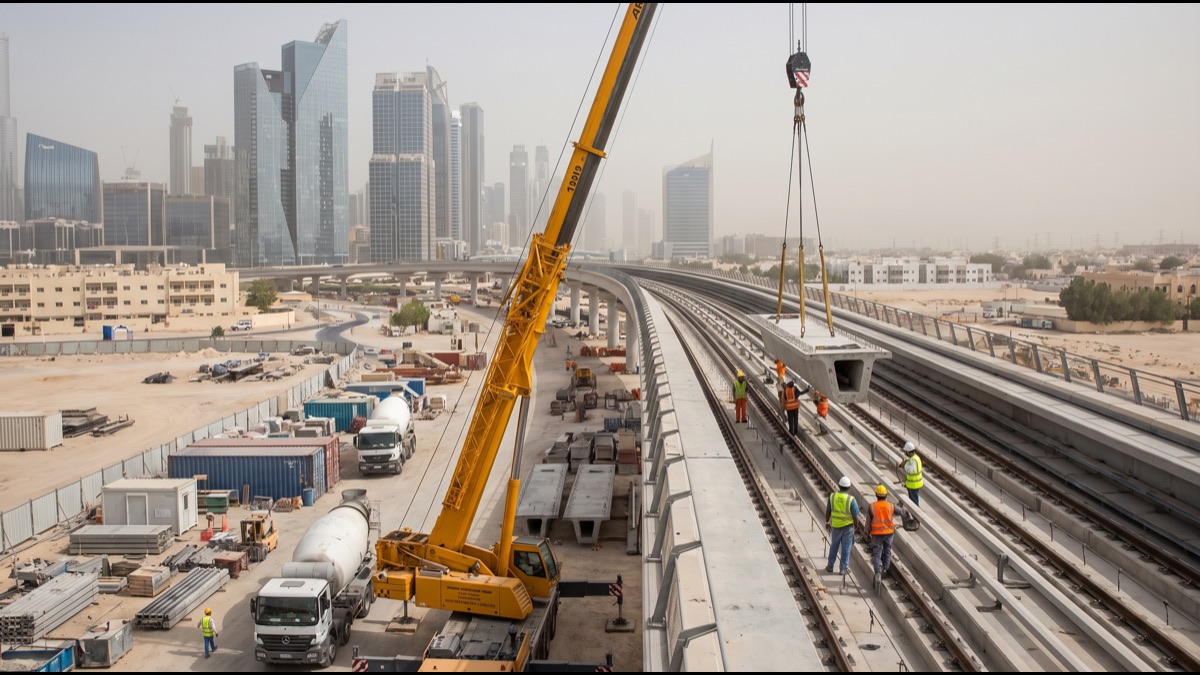
Dubai's Roads and Transport Authority is building the fifth line of the Dubai Metro network, the Blue Line, a roughly thirty kilometer route designed to connect fast growing residential districts in the east and southeast of the city to the existing rail network for the first time. Announced in 2024 and targeted for completion by the end of the decade, the Blue Line is one of the largest single infrastructure commitments Dubai has made since the original Metro opened in 2009. Understanding how it is actually routed, built, and expected to perform clarifies why the RTA considers it a priority rather than a nice-to-have expansion.
The Blue Line's Route and Where It Connects
The Blue Line is designed to run roughly 30 kilometers, tracing an arc through districts that have grown rapidly over the past decade but have never had direct Metro access, including Dubai Creek Harbour, Ras Al Khor, Dubai Silicon Oasis, Academic City, and Al Warqa.
Unlike the Red Line's largely linear path along Sheikh Zayed Road, the Blue Line curves through a mix of established residential neighborhoods and newly developed districts, reflecting how Dubai's population growth has increasingly moved toward the city's eastern and southeastern edges rather than concentrating along the original coastal corridor.
The route was planned specifically to plug a long-standing gap: large, densely populated areas east of Dubai Creek had relied entirely on road transport, contributing to some of the city's heaviest congestion corridors, particularly around Ras Al Khor and the routes feeding into Sheikh Zayed Road each morning.
Why the Blue Line Was Approved Now
The RTA's decision to move forward with the Blue Line in 2024 reflects population and development trends that have accelerated well beyond what the original two-line Metro network, designed around 2005 population projections, was built to handle.
Dubai's population has grown substantially since the Red and Green Lines opened, and much of that growth has concentrated in exactly the districts the Blue Line now serves, areas that were largely undeveloped land or low-density suburbs when the original Metro was designed.
Dubai Creek Harbour in particular has emerged as a major planned development anchored around a new downtown district, and its scale, along with continued growth in Dubai Silicon Oasis as a technology and residential hub, gave the RTA a clear economic case for extending rail access rather than relying solely on road widening.
How the Blue Line Links to the Red Line at Rashidiya
The Blue Line is designed to interchange with the Red Line at Rashidiya station, the Red Line's easternmost stop, creating a direct transfer point between the new line and the original network rather than requiring an entirely separate ticketing or platform system.
This interchange design means a passenger boarding at a Blue Line station in Dubai Silicon Oasis or Academic City can reach Downtown Dubai, Dubai Marina, or Dubai International Airport by transferring once at Rashidiya, without leaving the rail system or needing a connecting bus.
Choosing Rashidiya as the interchange point also reflects practical engineering considerations, since the station already has expansion capacity built into its original design, reducing the disruption and cost involved compared with retrofitting a busier, more central Red Line station.
The Elevated and Underground Construction Approach
Like the original Red and Green Lines, the Blue Line combines elevated viaduct sections with underground tunneled sections, with the specific mix determined by land availability, existing infrastructure, and population density along each stretch of the route.
Denser, more built-up sections of the corridor are generally planned for underground construction to avoid disrupting existing roads and buildings, while sections passing through newer or less developed areas, including stretches near Dubai Creek Harbour, are more likely to use elevated viaducts, which are faster and less expensive to build than tunnels.
This mixed approach mirrors how the original Metro lines were built and reflects a deliberate cost and speed tradeoff: tunneling is significantly more expensive per kilometer than elevated construction, so the RTA reserves it for sections where surface-level or elevated construction genuinely isn't feasible.
Driverless Trains and Signaling Technology
The Blue Line uses the same fully automated, driverless train technology that has operated on the Red and Green Lines since they opened, relying on automatic train control systems that manage acceleration, braking, and door operations without an onboard driver.
Platform screen doors, the glass barriers that separate the platform from the track and only open when a train is correctly aligned, are also planned for Blue Line stations, matching the safety standard used across the rest of the network rather than introducing a different system.
Keeping the signaling and rolling stock technology consistent across all lines simplifies maintenance, training, and network-wide software updates, and it also means Blue Line trains can, in principle, share maintenance depots and spare parts inventories with the existing fleet.
Stations Along the Blue Line and What They Serve
The Blue Line is planned with 14 stations, most named for the districts they serve, giving direct rail access to areas including Dubai Creek Harbour, Ras Al Khor Industrial Area, Dubai Silicon Oasis, Academic City, and Al Warqa, alongside intermediate stops serving smaller residential communities.
Academic City stations are specifically positioned to serve the cluster of international university campuses located there, a population of daily commuting students and staff who previously had no direct Metro option and relied heavily on private vehicles or university shuttle buses.
Stations near Ras Al Khor are also positioned close to the Ras Al Khor Wildlife Sanctuary and surrounding industrial and logistics zones, meaning the line is designed to serve a genuinely mixed set of commuting, residential, educational, and industrial trip purposes rather than a single dominant use case.
The Contractors and Scale of the Project
The Blue Line was awarded to a consortium of contractors with prior experience on Dubai's original Metro and later expansions, a deliberate choice by the RTA to build on established local construction expertise rather than starting from scratch with unfamiliar teams.
The project's estimated cost runs into the tens of billions of dirhams, reflecting both the scale of new track and stations being built and the cost of the specialized tunnel boring and elevated viaduct construction equipment required for a project of this size.
Construction of a project this size in an active, densely populated city requires extensive coordination with utility companies, road authorities, and existing property developments along the route, work that typically begins well before visible construction activity starts and continues throughout the build.
Timeline From Approval to Opening
Following its 2024 approval, the Blue Line entered a construction program the RTA has targeted for completion around 2029, a roughly five-year build timeline broadly comparable to the construction period for the original Red and Green Lines.
Major infrastructure projects of this scale typically move through distinct phases, including utility relocation, foundation and tunnel or viaduct construction, station fit-out, systems installation and testing, and finally a period of trial running before passenger service begins, each of which adds to the overall timeline.
While the RTA has stated a target completion year, large transit projects worldwide are frequently subject to schedule adjustments driven by unforeseen ground conditions, utility conflicts, or phased opening strategies where sections of a line begin operating before the entire route is complete.
Projected Ridership and Why the RTA Expects Growth
The RTA has projected the Blue Line will serve approximately 320,000 riders a day by the mid-2030s, a figure based on both current population growth trends in the districts it serves and continued planned development along the corridor.
This ridership projection reflects a broader pattern seen with new transit lines worldwide: rail access itself tends to accelerate development and population growth along a corridor, meaning ridership figures based purely on today's population in these districts would likely understate actual future demand.
Dubai Creek Harbour alone is planned to eventually house a population comparable to a mid-sized city, and the RTA's ridership modeling for the Blue Line explicitly accounts for that development reaching maturity within the projection window rather than assuming today's population levels persist unchanged.
How the Blue Line Fits the Dubai 2040 Urban Master Plan
The Blue Line is explicitly framed as an implementation piece of the Dubai 2040 Urban Master Plan, the city's long-range planning framework that designates urban centers, population growth corridors, and green and recreational space priorities through the year 2040.
That master plan identifies eastern Dubai, including the areas the Blue Line serves, as one of five major urban centers intended to absorb a substantial share of the city's future population growth, meaning the rail line is being built ahead of, not purely in response to, projected demand.
Aligning transit investment with a formal long-range urban plan is a deliberate strategy shift from Dubai's earlier, more reactive infrastructure approach, intended to ensure rail capacity exists before a district becomes fully built out rather than retrofitting transit into an already congested area.
Connecting East Dubai to the Rest of the City
Before the Blue Line, residents of Dubai Silicon Oasis, Academic City, and Al Warqa had no direct Metro access at all, relying on a combination of private vehicles, taxis, and RTA bus routes that fed into the nearest Red Line stations, adding meaningful travel time to any Metro-based commute.
This gap had real economic consequences, since Dubai Silicon Oasis specifically markets itself as a technology and innovation hub aiming to attract companies and talent, and the absence of direct rail access was a recognized disadvantage compared with commercial districts already well served by the Red Line.
Direct rail access is also expected to reduce car dependency in these districts specifically, an outcome the RTA has cited as aligned with Dubai's broader sustainability goals around reducing per-capita vehicle trips as the city's population continues to grow.
Comparing the Blue Line to the Red and Green Lines
The original Red Line, opened in 2009, runs largely along Sheikh Zayed Road connecting the airport, Downtown Dubai, and Dubai Marina, while the Green Line, opened later the same year, serves older, more established districts including Deira and Bur Dubai.
The Blue Line differs from both in that it primarily serves newer, still-developing districts rather than already dense, established urban corridors, meaning its ridership growth curve is expected to look different, starting lower at opening and climbing over subsequent years as surrounding development matures.
Where the Red and Green Lines were built essentially from scratch as the first rail transit the city had ever had, the Blue Line benefits from an established operational network, existing maintenance infrastructure, and a proven ridership base already using the Metro daily, reducing some of the adoption uncertainty new transit systems typically face.
Property and Economic Impact Along the Corridor
Property developers and analysts in Dubai have widely noted that Metro proximity has historically correlated with property value premiums along the Red and Green Line corridors, a pattern the real estate market is already pricing into developments near planned Blue Line stations.
Dubai Creek Harbour's developer has specifically marketed direct Metro connectivity as a selling point for the district's residential and commercial towers, reflecting how transit access has become an expected amenity for major master-planned developments in the city rather than an afterthought.
Beyond residential property, businesses in Dubai Silicon Oasis and Academic City are expected to benefit from improved access to talent that previously found the commute impractical without a private vehicle, a factor that regional economic development bodies have cited as relevant to attracting international companies and students.
Environmental and Sustainability Considerations
Expanding rail transit is generally understood to reduce per-passenger carbon emissions compared with private vehicle trips, a factor the RTA has cited in the context of Dubai's broader environmental commitments, including targets tied to the UAE's national net-zero strategy.
Construction of a project this scale does carry its own environmental footprint, including materials production, land disturbance, and the logistics involved in building tens of kilometers of track, tunnels, and elevated structures, costs that are generally weighed against the multi-decade emissions reduction the completed line is expected to deliver.
Stations near Ras Al Khor required particular attention to the adjacent wildlife sanctuary, a protected wetland habitat for flamingos and other migratory birds, with construction planning intended to limit disruption to the site during the build.
Challenges of Building a Metro in a Growing City
Building major rail infrastructure through an actively developing, densely populated city presents challenges distinct from greenfield construction, including coordinating with existing utility networks, minimizing disruption to active roads, and sequencing work around neighborhoods where people already live and work.
Utility relocation, moving water, power, and telecommunications infrastructure out of the path of tunnels and station foundations, is typically one of the most time-consuming early phases of a project like this, often taking many months before visible above-ground construction begins.
Dubai's experience building the original Red and Green Lines gave the RTA and its contractors direct institutional knowledge of managing these challenges at scale, a factor generally considered to reduce risk on the Blue Line relative to a city building its first rail system without that prior experience.
What Comes After the Blue Line
The RTA has indicated the Blue Line is part of a longer-term vision for continued Metro network expansion, with additional lines and extensions under discussion as Dubai's population and urban footprint continue growing beyond current projections.
Network effects tend to compound with each new line, since additional lines increase the number of possible interchange journeys across the system, meaning the Blue Line's value is expected to grow not just from its own ridership but from how it strengthens connectivity across the entire Metro network.
Transit planners generally view a five-line network, once complete, as a meaningful threshold for a city's rail system, one that allows the majority of major population and employment centers to be reached without a private vehicle, a milestone Dubai has been building toward since the Metro's 2009 launch.
The Blue Line represents a shift in how Dubai is thinking about transit: rather than reacting to congestion after it becomes a serious problem, the RTA is extending rail access ahead of full district build-out, betting that transit-oriented growth produces a better outcome than retrofitting rail into an already congested area later. Its success will depend on execution through a challenging five-year build, but the underlying logic, connecting the city's fastest-growing districts to its existing rail network before they reach full density, reflects lessons learned from two decades of Dubai's own explosive urban growth.
Sources
- Roads and Transport Authority, Dubai — Official information on the Dubai Metro Blue Line project.
- Dubai 2040 Urban Master Plan — Dubai's long-range urban planning framework and growth corridor designations.
- The Official Portal of the UAE Government — National context on UAE infrastructure and transport policy.
- Gulf News — Regional reporting on Dubai Metro Blue Line construction milestones.
FAQ
How long is Dubai's Metro Blue Line?
The Blue Line runs approximately 30 kilometers with 14 stations, connecting Dubai Creek Harbour, Ras Al Khor, Dubai Silicon Oasis, Academic City, and Al Warqa to the existing Metro network.
Where does the Blue Line connect to the Red Line?
The Blue Line interchanges with the Red Line at Rashidiya station, allowing passengers to transfer between the two lines to reach destinations across greater Dubai without leaving the rail system.
When will the Blue Line open?
The RTA has targeted 2029 for the Blue Line's opening, following a construction program that began after the project's 2024 approval, similar in duration to the original Red and Green Lines.
Will Blue Line trains be driverless like the rest of the Metro?
Yes, the Blue Line uses the same fully automated, driverless train technology and platform screen door safety system already deployed on the Red and Green Lines.
How many daily riders is the Blue Line expected to serve?
The RTA has projected the Blue Line will serve roughly 320,000 riders a day by the mid-2030s, reflecting the fast population growth already underway along its corridor.
About the Author
We reference the Roads and Transport Authority of Dubai, the Dubai 2040 Urban Master Plan, the UAE government's official portal, and regional reporting to explain the background and current understanding of this topic.
Loved This Article?
Share it on WhatsApp → Share it on WhatsApp
Get more guides in your inbox — Subscribe to our newsletter for weekly surprising stories from Egypt, Saudi Arabia, Dubai, and beyond.